
Gracias por apoyar a este sitio ❤️
Haz una donación
Haz una donación
Mapa topográfico Quebec
Haga clic en el mapa para ver la altitud.
Gracias por apoyar a este sitio ❤️
Haz una donación
Haz una donación
Quebec
La topografía de la ciudad constituye, por un extremo, la colina de Quebec, donde se encuentran los municipios de Sainte-Foy - Sillery - Cap-Rouge y La Cité-Limoilou (en parte), y por el otro extremo, la ladera de Beauport, que influyó fuertemente en la ocupación del territorio.
Gracias por apoyar a este sitio ❤️
Haz una donación
Haz una donación
Acerca de este mapa
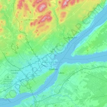
Nombre: Mapa topográfico Quebec, altitud, relieve.
Altitud media: 117 m
Altitud mínima: -3 m
Altitud máxima: 629 m
Gracias por apoyar a este sitio ❤️
Haz una donación
Haz una donación