
Gracias por apoyar a este sitio ❤️
Haz una donación
Haz una donación
Mapa topográfico Udaipur
Haga clic en el mapa para ver la altitud.
Gracias por apoyar a este sitio ❤️
Haz una donación
Haz una donación
Acerca de este mapa
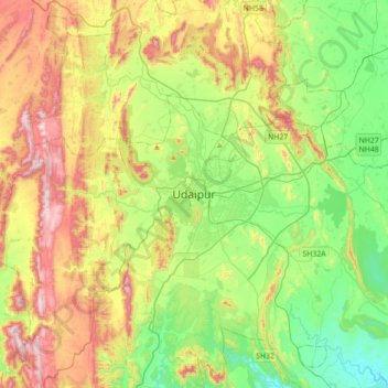
Nombre: Mapa topográfico Udaipur, altitud, relieve.
Lugar: Udaipur, Girwa Tehsil, Udaipur, Rajastán, 313001, India (24.41872 73.52626 24.73872 73.84626)
Altitud media: 656 m
Altitud mínima: 408 m
Altitud máxima: 1 067 m
Gracias por apoyar a este sitio ❤️
Haz una donación
Haz una donación