
Mapa topográfico Ely
Mapa interactivo
Haga clic en el mapa para ver la altitud.
Acerca de este mapa
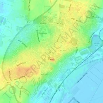
Nombre: Mapa topográfico Ely, altitud, relieve.
Lugar: Ely, Cambridgeshire, East of England, England, United Kingdom (52.38615 0.24029 52.41585 0.28644)
Altitud media: 13 m
Altitud mínima: -4 m
Altitud máxima: 29 m
For over 800 years the cathedral and its associated buildings—built on an elevation 68 feet (21 m) above the nearby fens—have visually influenced the city and its surrounding area. Geographer John Jones, writing in 1924, reports that "from the roof of King's Chapel in Cambridge, on a clear day, Ely can be seen on the horizon, 16 miles (26 km) distant, an expression of the flatness of the fens". In 1954, architectural historian Nikolaus Pevsner wrote "as one approaches Ely on foot or on a bicycle, or perhaps in an open car, the cathedral dominates the picture for miles around … and offers from everywhere an outline different from that of any other English cathedral". Local historian Pamela Blakeman reports a claim that "Grouped around … is the largest collection of mediaeval buildings still in daily use in this country".
Otros mapas topográficos
Haga clic en un mapa para ver su topografía, su altitud y su relieve.
Chettisham
United Kingdom > England > Ely
Chettisham, Ely, East Cambridgeshire, Cambridgeshire, Cambridgeshire and Peterborough, England, United Kingdom
Altitud media: 9 m