
Mapa topográfico Brittany
Mapa interactivo
Haga clic en el mapa para ver la altitud.
Acerca de este mapa
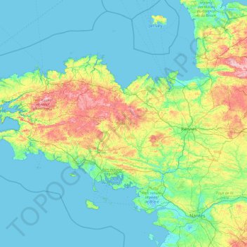
Nombre: Mapa topográfico Brittany, altitud, relieve.
Altitud media: 50 m
Altitud mínima: -3 m
Altitud máxima: 371 m
The Armorican massif reaches its maximal elevation outside of Brittany, in neighbouring Mayenne, at 417 m, and slopes towards the west before straightening on its western extremity, with the Montagnes Noires and the Monts d'Arrée. The highest hill in Brittany is the Roc'h Ruz in the Monts d'Arrée, at 385 m (1,263 ft). It is closely followed by several neighbouring hills culminating at around 384 m above sea level.