
Mapa topográfico Valencia
Mapa interactivo
Haga clic en el mapa para ver la altitud.
Acerca de este mapa
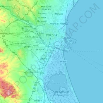
Nombre: Mapa topográfico Valencia, altitud, relieve.
Altitud media: 37 m
Altitud mínima: -6 m
Altitud máxima: 346 m
The maximum of precipitation occurs in the Autumn, coinciding with the time of the year when cold drop (gota fría) episodes of heavy rainfall—associated to cut-off low pressure systems at high altitude— are common along the Western mediterranean coast. The year-on-year variability in precipitation may be, however, considerable.
Otros mapas topográficos
Haga clic en un mapa para ver su topografía, su altitud y su relieve.
Platja del Cabanyal - Les Arenes
Spain > Valencian Community > Comarca de València > Valencia
Platja del Cabanyal - Les Arenes, Poblats Marítims, Valencia, Comarca de València, Valencia, Valencian Community, Spain
Altitud media: 2 m