
Mapa topográfico Lonlay-l'Abbaye
Mapa interactivo
Haga clic en el mapa para ver la altitud.
Acerca de este mapa
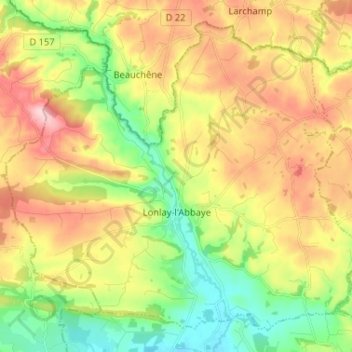
Nombre: Mapa topográfico Lonlay-l'Abbaye, altitud, relieve.
Altitud media: 214 m
Altitud mínima: 123 m
Altitud máxima: 326 m
Otros mapas topográficos
Haga clic en un mapa para ver su topografía, su altitud y su relieve.
Tinchebray
France > Normandy > Orne > Tinchebray-Bocage
Tinchebray, Tinchebray-Bocage, Argentan, Orne, Normandy, Metropolitan France, 61800, France
Altitud media: 238 m
Neuvy-au-Houlme
Neuvy-au-Houlme, Argentan, Orne, Normandy, Metropolitan France, 61210, France
Altitud media: 192 m
Saint-Langis-lès-Mortagne
France > Normandy > Orne > Saint-Langis-lès-Mortagne
Saint-Langis-lès-Mortagne, Mortagne-au-Perche, Orne, Normandy, Metropolitan France, 61400, France
Altitud media: 206 m
Les Monts-d'Andaine
France > Normandy > Orne > Les Monts-d'Andaine
Les Monts-d'Andaine, Argentan, Orne, Normandy, Metropolitan France, 61600, France
Altitud media: 244 m
La Perrière
France > Normandy > Orne > Belforêt-en-Perche
La Perrière, Belforêt-en-Perche, Mortagne-au-Perche, Orne, Normandy, Metropolitan France, 61360, France
Altitud media: 174 m
Tinchebray-Bocage
Tinchebray-Bocage, Argentan, Orne, Normandy, Metropolitan France, 61800, France
Altitud media: 256 m
Chambois
France > Normandy > Orne > Gouffern en Auge
Chambois, Gouffern en Auge, Argentan, Orne, Normandy, Metropolitan France, 61160, France
Altitud media: 115 m