
Mapa topográfico Damavand
Mapa interactivo
Haga clic en el mapa para ver la altitud.
Acerca de este mapa
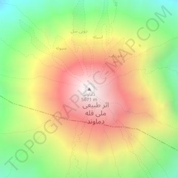
Nombre: Mapa topográfico Damavand, altitud, relieve.
Altitud media: 4 946 m
Altitud mínima: 4 310 m
Altitud máxima: 5 595 m
Mount Damavand (Persian: دماوند [dæmɒːvænd] (listen)) is a potentially active stratovolcano, the highest peak in Iran and Western Asia and the highest volcano in Asia and the 2nd highest volcano in the Eastern Hemisphere (after Mount Kilimanjaro), at an elevation of 5,671 metres (18,606 ft). Damāvand has a special place in Persian mythology and folklore. It is in the middle of the Alborz range, adjacent to Varārū, Sesang, Gol-e Zard, and Mīānrūd. It is near the southern coast of the Caspian Sea, in Amol County, Mazandaran Province, 66 km (41 mi) northeast of the city of Tehran.
Otros mapas topográficos
Haga clic en un mapa para ver su topografía, su altitud y su relieve.
Namar
Iran > Mazandaran Province > Amol County > دهستان لاریجان سفلی > Namar
Namar, دهستان لاریجان سفلی, بخش لاریجان, Amol County, Mazandaran Province, Iran
Altitud media: 2 452 m
دهستان لاریجان سفلی
Iran > Mazandaran Province > Amol County > دهستان لاریجان سفلی
دهستان لاریجان سفلی, بخش لاریجان, Amol County, Mazandaran Province, Iran
Altitud media: 2 569 m