
Mapa topográfico Gajwel
Mapa interactivo
Haga clic en el mapa para ver la altitud.
Acerca de este mapa
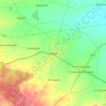
Nombre: Mapa topográfico Gajwel, altitud, relieve.
Altitud media: 568 m
Altitud mínima: 532 m
Altitud máxima: 620 m
The town is located on the Deccan Plateau and is surrounded by agricultural lands. It lies at an average elevation of around 540 meters (1,770 feet) above sea level. The area is characterized by undulating terrain with scattered hills and valleys.