
Mapa topográfico Bamberton
Mapa interactivo
Haga clic en el mapa para ver la altitud.
Acerca de este mapa
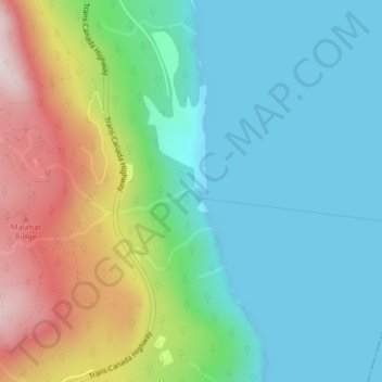
Nombre: Mapa topográfico Bamberton, altitud, relieve.
Altitud media: 162 m
Altitud mínima: 0 m
Altitud máxima: 544 m
Otros mapas topográficos
Haga clic en un mapa para ver su topografía, su altitud y su relieve.
Spectacle Lake Provincial Park
Canada > British Columbia > Area A (Mill Bay / Malahat)
Spectacle Lake Provincial Park, Cedarwood, Spectacle Lake Home Park, Area A (Mill Bay / Malahat), Cowichan Valley Regional District, British Columbia, V0R 2L0, Canada
Altitud media: 429 m