
Haz una donación
Mapa topográfico Kaluga Oblast
Haga clic en el mapa para ver la altitud.
Haz una donación
Kaluga Oblast
Kaluga Oblast lies in the central part of the East European Plain. The oblast's territory is located between the Central Russian Upland (with and average elevation of above 200 metres (660 ft) and a maximum elevation of 275 metres (902 ft) in the southeast), the Smolensk–Moscow Upland and the Dnieper–Desna watershed. Most of the oblast is occupied by plains, fields and forests with diverse flora and fauna. The administrative center is located on the Baryatino-Sukhinichy plain. The western part of the oblast — located within the drift plain — is dominated by the Spas-Demensk ridge. To the south is an outwash plain that is part of the Bryansk-Zhizdra woodlands, with average elevation up to 200 m.
Haz una donación
Acerca de este mapa
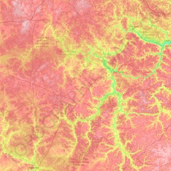
Nombre: Mapa topográfico Kaluga Oblast, altitud, relieve.
Lugar: Kaluga Oblast, Central Federal District, Russia (53.27699 33.44139 55.35128 37.27543)
Altitud media: 204 m
Altitud mínima: 107 m
Altitud máxima: 311 m
Haz una donación
Otros mapas topográficos
Haga clic en un mapa para ver su topografía, su altitud y su relieve.