
Mapa topográfico Waynesville
Mapa interactivo
Haga clic en el mapa para ver la altitud.
Acerca de este mapa
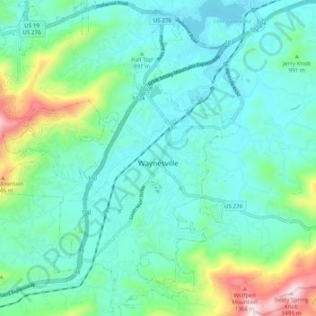
Nombre: Mapa topográfico Waynesville, altitud, relieve.
Altitud media: 921 m
Altitud mínima: 772 m
Altitud máxima: 1 484 m
Most of the town of Waynesville lies between 2,600 and 3,000 feet (790 and 910 m) above sea level, in a valley among 5,000-to-6,410-foot (1,520 to 1,950 m) mountain peaks. With the high Great Balsam Mountains to the WSW, and the Plott Balsams to the WNW, a handful of peaks over 6000' in elevation are clearly visible from town. A USGS survey marker at the old Haywood County Courthouse in downtown Waynesville lists the elevation as 2,752 feet (839 m) above sea level.