
Mapa topográfico Seixal
Mapa interactivo
Haga clic en el mapa para ver la altitud.
Acerca de este mapa
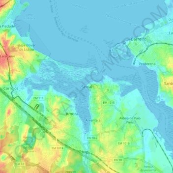
Nombre: Mapa topográfico Seixal, altitud, relieve.
Altitud media: 43 m
Altitud mínima: -3 m
Altitud máxima: 462 m
Although the municipal population continued to grow with development, after the 1970s there was a boom in the population, due to improvements in accessibility and mobility, principally due to public transport, its location to Lisbon and installation of economic activities within the territory. This growth transformed, in a short time, from a territory predominantly rural into an urban municipality, consisting of agglomerations of large dimensions focusing on various establishments and social centres. This growth resulted in the 1993 elevation of Seixal and Amora into cities, and the establishment of Corroios into the status of town.
Otros mapas topográficos
Haga clic en un mapa para ver su topografía, su altitud y su relieve.
Alto do Moinho
Portugal > Setúbal > Seixal > Corroios
Alto do Moinho, Corroios, Seixal, Setúbal, 2855-719, Portugal
Altitud media: 36 m