
Mapa topográfico Highland County
Mapa interactivo
Haga clic en el mapa para ver la altitud.
Acerca de este mapa
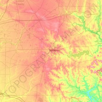
Nombre: Mapa topográfico Highland County, altitud, relieve.
Lugar: Highland County, Ohio, United States of America (39.01846 -83.87217 39.37876 -83.34395)
Altitud media: 305 m
Altitud mínima: 203 m
Altitud máxima: 401 m
Highland County is a county located in the U.S. state of Ohio. As of the 2010 census, the population was 43,589. Its county seat is Hillsboro. The county is named for the topography which is hilly and divides the watersheds of the Little Miami and Scioto Rivers.
Otros mapas topográficos
Haga clic en un mapa para ver su topografía, su altitud y su relieve.
Williams County
United States of America > Ohio
Williams County, Ohio, United States of America
Altitud media: 259 m
Defiance County
United States of America > Ohio
Defiance County, Ohio, United States of America
Altitud media: 225 m
Beechgrove
United States of America > Ohio > Beechgrove
Beechgrove, Darke County, Ohio, United States of America
Altitud media: 330 m
Toledo
United States of America > Ohio > Toledo
Toledo, Lucas County, Ohio, United States of America
Altitud media: 185 m
Medina County
United States of America > Ohio
Medina County, Ohio, United States of America
Altitud media: 306 m