
Mapa topográfico Huesca
Mapa interactivo
Haga clic en el mapa para ver la altitud.
Acerca de este mapa
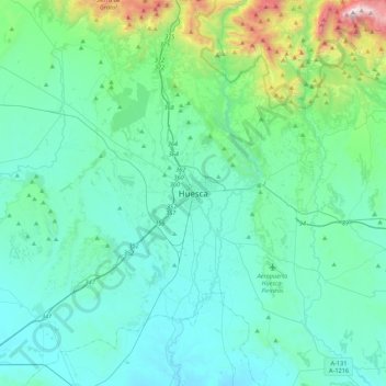
Nombre: Mapa topográfico Huesca, altitud, relieve.
Altitud media: 589 m
Altitud mínima: 343 m
Altitud máxima: 2 062 m
Huesca lies on a plateau in the northern region of Aragón, with an elevation of 488 m (1,601.05 ft) above sea level. Close to the city lie the Sierra de Guara mountains, which reach 2,077 m. The geographical coordinates of the city are: 42° 08´ N, 0° 24´ W.