Mapa topográfico Rhode
Mapa interactivo
Haga clic en el mapa para ver la altitud.
Acerca de este mapa
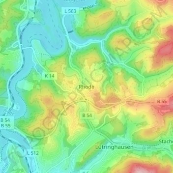
Nombre: Mapa topográfico Rhode, altitud, relieve.
Lugar: Rhode, Olpe, Kreis Olpe, Nordrhein-Westfalen, 57462, Deutschland (51.03058 7.84047 51.07058 7.88047)
Altitud media: 372 m
Altitud mínima: 305 m
Altitud máxima: 503 m
Otros mapas topográficos
Haga clic en un mapa para ver su topografía, su altitud y su relieve.
Neuenkleusheim
Deutschland > Nordrhein-Westfalen > Kreis Olpe > Olpe
Neuenkleusheim, Olpe, Kreis Olpe, Nordrhein-Westfalen, Deutschland
Altitud media: 447 m
Friedrichsthal
Deutschland > Nordrhein-Westfalen > Kreis Olpe > Olpe
Friedrichsthal, Olpe, Kreis Olpe, Nordrhein-Westfalen, 57462, Deutschland
Altitud media: 389 m
Schlammborn
Deutschland > Nordrhein-Westfalen > Kreis Olpe > Olpe
Schlammborn, Olpe, Kreis Olpe, Nordrhein-Westfalen, 57462, Deutschland
Altitud media: 394 m
Rüblinghausen
Deutschland > Nordrhein-Westfalen > Kreis Olpe > Olpe
Rüblinghausen, Olpe, Kreis Olpe, Nordrhein-Westfalen, 57462, Deutschland
Altitud media: 371 m
Attenberg
Deutschland > Nordrhein-Westfalen > Kreis Olpe > Olpe
Attenberg, Olpe, Kreis Olpe, Nordrhein-Westfalen, 57462, Deutschland
Altitud media: 395 m
Nocken
Deutschland > Nordrhein-Westfalen > Kreis Olpe > Olpe
Nocken, Olpe, Kreis Olpe, Nordrhein-Westfalen, 57462, Deutschland
Altitud media: 435 m
Fahlenscheid
Deutschland > Nordrhein-Westfalen > Kreis Olpe > Olpe
Fahlenscheid, Olpe, Kreis Olpe, Nordrhein-Westfalen, Deutschland
Altitud media: 497 m
Altenkleusheim
Deutschland > Nordrhein-Westfalen > Kreis Olpe > Olpe
Altenkleusheim, Olpe, Kreis Olpe, Nordrhein-Westfalen, Deutschland
Altitud media: 441 m
Höchsten
Deutschland > Nordrhein-Westfalen > Kreis Olpe > Olpe
Höchsten, Olpe, Kreis Olpe, Nordrhein-Westfalen, 57462, Deutschland
Altitud media: 431 m