
Mapa topográfico Grande Prairie
Mapa interactivo
Haga clic en el mapa para ver la altitud.
Acerca de este mapa
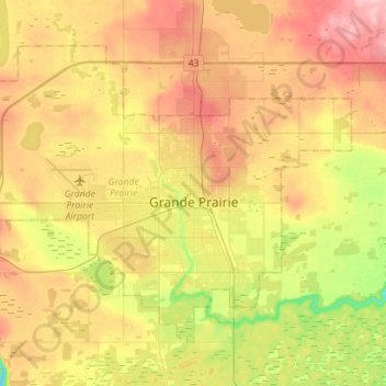
Nombre: Mapa topográfico Grande Prairie, altitud, relieve.
Lugar: Grande Prairie, Division No. 19, Alberta, Canada (55.11247 -118.96176 55.23618 -118.67955)
Altitud media: 665 m
Altitud mínima: 600 m
Altitud máxima: 726 m
Grande Prairie is located just north of the 55th parallel north, and is 465 km (289 mi) northwest of Edmonton, lying at an elevation of 669 m (2,195 ft) above sea level. The city is surrounded by farmland to the north, east, and west. To the south lies a vast boreal forest with aspen, tamarack, lodgepole pine, jack pine, and black spruce extending well into the foothills of the Canadian Rockies south and southwest of the city.
Otros mapas topográficos
Haga clic en un mapa para ver su topografía, su altitud y su relieve.
Clairmont
Canada > Alberta > Division No. 19 > Hamlet of Clairmont
Clairmont, Hamlet of Clairmont, Division No. 19, Alberta, T0H 0W0, Canada
Altitud media: 679 m
Village of Donnelly
Canada > Alberta > Division No. 19
Village of Donnelly, Division No. 19, Alberta, Canada
Altitud media: 594 m
Beaverlodge
Canada > Alberta > Division No. 19
Beaverlodge, Division No. 19, Alberta, T0H 0C0, Canada
Altitud media: 735 m
La Glace
Canada > Alberta > Division No. 19
La Glace, Division No. 19, Alberta, T0H 2J0, Canada
Altitud media: 738 m