
Mapa topográfico Jaca
Mapa interactivo
Haga clic en el mapa para ver la altitud.
Acerca de este mapa
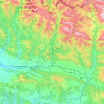
Nombre: Mapa topográfico Jaca, altitud, relieve.
Lugar: Jaca, Jacetania, Huesca, Aragon, Spain (42.41503 -0.70159 42.82795 -0.39912)
Altitud media: 1 223 m
Altitud mínima: 576 m
Altitud máxima: 2 993 m
Jaca has an submediterranean climate (Köppen: Cfb) bordering a submediterranean climate (Köppen: Cfa) with strong continental influences caused by the city's high altitude of 820 metres (2,690 ft). Winters are cool and summers are warm, with hot daytime temperatures but relatively cool nights. There isn't any real dry season, but the rainiest seasons are autumn and spring. The average precipitation is 768 millimetres (30.2 in) per year. Frost is common so is snowfall, being snow common from late November to early March. Heavy snowfalls are sporadic, and they usually occur during cold spells. Jaca's average annual temperature is 12.2 °C (54.0 °F).
Otros mapas topográficos
Haga clic en un mapa para ver su topografía, su altitud y su relieve.