
Mapa topográfico Ladismith
Mapa interactivo
Haga clic en el mapa para ver la altitud.
Acerca de este mapa
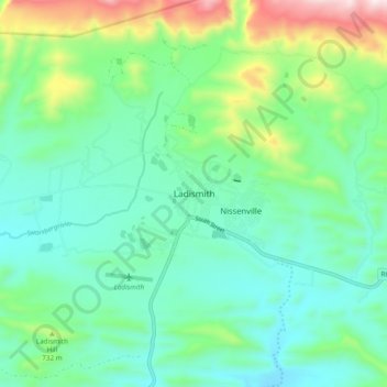
Nombre: Mapa topográfico Ladismith, altitud, relieve.
Altitud media: 605 m
Altitud mínima: 426 m
Altitud máxima: 1 132 m
It is situated adjacent to a series of fertile, irrigated valleys, at an elevation of 550 m above sea level, at the southern base of the Swartberg. It is currently included in the southern Kannaland Local Municipality. The nearest towns are Calitzdorp to the east, Vanwyksdorp and Riversdale to the south and Laingsburg to the north.
Otros mapas topográficos
Haga clic en un mapa para ver su topografía, su altitud y su relieve.
Van Wyksdorp
South Africa > Western Cape > Garden Route District Municipality > Kannaland Local Municipality
Van Wyksdorp, Kannaland Local Municipality, Garden Route District Municipality, Western Cape, South Africa
Altitud media: 251 m
Calitzdorp
South Africa > Western Cape > Garden Route District Municipality > Kannaland Local Municipality
Calitzdorp, Kannaland Local Municipality, Garden Route District Municipality, Western Cape, South Africa
Altitud media: 307 m