
Mapa topográfico Shahrud
Mapa interactivo
Haga clic en el mapa para ver la altitud.
Acerca de este mapa
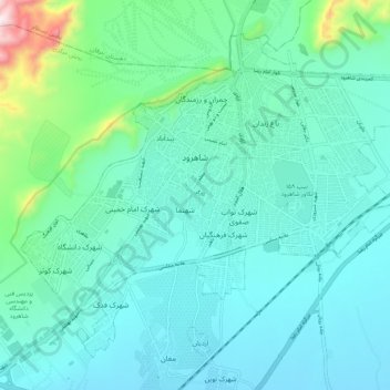
Nombre: Mapa topográfico Shahrud, altitud, relieve.
Lugar: Shahrud, بخش مرکزی, Shahrud County, Semnan Province, Iran (36.37551 54.91737 36.44660 55.02354)
Altitud media: 1 375 m
Altitud mínima: 1 265 m
Altitud máxima: 1 940 m
Situated about an altitude of 1345 m, it is located at latitude 36°25'N, longitude 055°01'E. The main launch site of the Iranian Space Agency is near Shahrood. It is also well known for unique types of grapes which are cultivated specially in Shahrud. Consequently, Shahrood is known as the City of Grapes.
Otros mapas topográficos
Haga clic en un mapa para ver su topografía, su altitud y su relieve.
خرقان
Iran > Semnan Province > Shahrud County > دهستان خرقان
خرقان, دهستان خرقان, بخش بسطام, Shahrud County, Semnan Province, Iran
Altitud media: 1 514 m
دهستان طرود
Iran > Semnan Province > Shahrud County
دهستان طرود, بخش مرکزی, Shahrud County, Semnan Province, Iran
Altitud media: 941 m
Bastam
Iran > Semnan Province > Shahrud County > دهستان خرقان
Bastam, دهستان خرقان, بخش بسطام, Shahrud County, Semnan Province, Iran
Altitud media: 1 434 m
Shahrud
Iran > Semnan Province > Shahrud County > Shahrud
Shahrud, بخش مرکزی, Shahrud County, Semnan Province, Iran
Altitud media: 1 510 m