
Mapa topográfico Moros
Mapa interactivo
Haga clic en el mapa para ver la altitud.
Acerca de este mapa
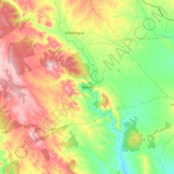
Nombre: Mapa topográfico Moros, altitud, relieve.
Lugar: Moros, Comunidad de Calatayud, Zaragoza, Aragon, Spain (41.36687 -1.91315 41.42871 -1.75219)
Altitud media: 777 m
Altitud mínima: 586 m
Altitud máxima: 1 013 m
Moros is one of the most attractive and picturesque villages of its kind in the area. Its narrow streets zigzag from the square at its highest elevation down to the river bed below. The houses are the main feature of the town. Hundreds of houses have been built tightly against the sunny side of the mountain. They are built with mud and decorated with red and ochre Arabic tiles. Each level of houses rises above the one beneath it to catch the sun as it rises over the valley.
Otros mapas topográficos
Haga clic en un mapa para ver su topografía, su altitud y su relieve.
Calatayud
Spain > Aragon > Comunidad de Calatayud
Calatayud, Comunidad de Calatayud, Zaragoza, Aragon, 50300, Spain
Altitud media: 693 m
Ariza
Spain > Aragon > Comunidad de Calatayud
Ariza, Comunidad de Calatayud, Zaragoza, Aragon, 50220, Spain
Altitud media: 801 m
Mara
Spain > Aragon > Comunidad de Calatayud
Mara, Comunidad de Calatayud, Zaragoza, Aragon, Spain
Altitud media: 773 m
Alhama de Aragón
Spain > Aragon > Comunidad de Calatayud > Alhama de Aragón
Alhama de Aragón, Comunidad de Calatayud, Zaragoza, Aragon, Spain
Altitud media: 763 m