
Mapa topográfico Alvor
Mapa interactivo
Haga clic en el mapa para ver la altitud.
Acerca de este mapa
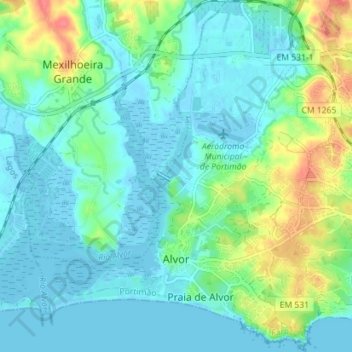
Nombre: Mapa topográfico Alvor, altitud, relieve.
Lugar: Alvor, Portimão, Faro, Portugal (37.11415 -8.62157 37.17064 -8.56067)
Altitud media: 15 m
Altitud mínima: -3 m
Altitud máxima: 62 m
The Prince Regent ordered, in the name of Manuel of Portugal, the elevation of Alvor to vila (town) on 28 February 1495, which was confirmed in a secondary diploma on 28 December 1498.
Otros mapas topográficos
Haga clic en un mapa para ver su topografía, su altitud y su relieve.
Mexilhoeira Grande
Mexilhoeira Grande, Portimão, Faro, 8500-130, Portugal
Altitud media: 28 m