
Mapa topográfico Lorton
Mapa interactivo
Haga clic en el mapa para ver la altitud.
Acerca de este mapa
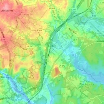
Nombre: Mapa topográfico Lorton, altitud, relieve.
Lugar: Lorton, Fairfax County, Virginia, United States (38.66687 -77.28193 38.73371 -77.19295)
Altitud media: 41 m
Altitud mínima: -4 m
Altitud máxima: 107 m
According to the United States Census Bureau, the Lorton CDP has a total area of 5.4 square miles (13.9 km2), of which 5.3 square miles (13.7 km2) is land and 0.1 square miles (0.2 km2), or 1.39%, is water. The elevation ranges from sea level at the Prince William County line (the Occoquan River) to slightly over 200 feet (61 m) along Furnace Road at the CDP's western edge.
Otros mapas topográficos
Haga clic en un mapa para ver su topografía, su altitud y su relieve.
Oakton
United States > Virginia > Fairfax County
Oakton, Fairfax County, Virginia, 20030, United States
Altitud media: 114 m
Springfield
United States > Virginia > Fairfax County > Springfield
Springfield, Fairfax County, Virginia, 22150, United States
Altitud media: 68 m