
Mapa topográfico Dezful
Mapa interactivo
Haga clic en el mapa para ver la altitud.
Acerca de este mapa
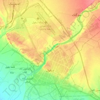
Nombre: Mapa topográfico Dezful, altitud, relieve.
Lugar: Dezful, بخش مرکزی, Dezful County, Khuzestan Province, Iran (32.34519 48.34017 32.45861 48.48374)
Altitud media: 137 m
Altitud mínima: 105 m
Altitud máxima: 169 m
Dezful is 650 kilometers away from the national capital of Tehran and 155 kilometres away from the provincial capital of Ahvaz. The city is located 300 kilometres from the Persian Gulf and is at an altitude of 143 meters.
Otros mapas topográficos
Haga clic en un mapa para ver su topografía, su altitud y su relieve.
دره ارواح
Iran > Khuzestan Province > Dezful County > دهستان شهی > Bisheh Bozān
دره ارواح, Bisheh Bozān, دهستان شهی, بخش شهیون, Dezful County, Khuzestan Province, Iran
Altitud media: 593 m
Jateh
Iran > Khuzestan Province > Dezful County
Jateh, بخش مرکزی, Dezful County, Khuzestan Province, 64617-98691, Iran
Altitud media: 116 m