
Mapa topográfico Golan Heights
Mapa interactivo
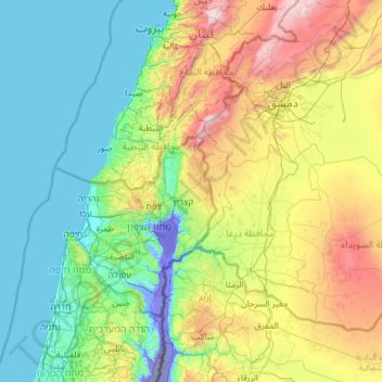
Haga clic en el mapa para ver la altitud.
Acerca de este mapa
Nombre: Mapa topográfico Golan Heights, altitud, relieve.
Altitud media: 533 m
Altitud mínima: -357 m
Altitud máxima: 2 777 m
The plateau that Israel controls is part of a larger area of volcanic basalt fields stretching north and east that were created in the series of volcanic eruptions that began recently in geological terms, almost 4 million years ago.[205] The rock forming the mountainous area in the northern Golan Heights, descending from Mount Hermon, differs geologically from the volcanic rocks of the plateau and has a different physiography. The mountains are characterised by lighter-colored, Jurassic-age limestone of sedimentary origin. Locally, the limestone is broken by faults and solution channels to form a karst-like topography in which springs are common.
Otros mapas topográficos
Haga clic en un mapa para ver su topografía, su altitud y su relieve.
Mount Hermon
Israel > North District > Golan Regional Council
Mount Hermon, Golan Regional Council, Golan Heights Subdistrict, North District, Israel
Altitud media: 1 741 m
Mt. Hermon
Israel > North District > Golan Regional Council
Mt. Hermon, Golan Regional Council, North District, Israel
Altitud media: 2 016 m