
Mapa topográfico Kilcurriv Eighter
Mapa interactivo
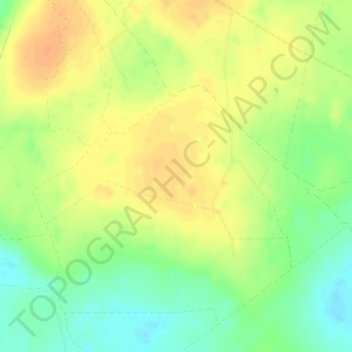
Haga clic en el mapa para ver la altitud.
Acerca de este mapa
Nombre: Mapa topográfico Kilcurriv Eighter, altitud, relieve.
Altitud media: 48 m
Altitud mínima: 28 m
Altitud máxima: 62 m
Otros mapas topográficos
Haga clic en un mapa para ver su topografía, su altitud y su relieve.
Renmore
Ireland > County Galway > Galway
Renmore, Galway, County Galway, Connacht, H91 V25X, Ireland
Altitud media: 11 m
Clonbern
Clonbern, Clonbern ED, Tuam Municipal District, County Galway, Connacht, Ireland
Altitud media: 75 m
NUIG Organic Garden
Ireland > County Galway > Galway
NUIG Organic Garden, Newcastle, Galway, County Galway, Connacht, Ireland
Altitud media: 15 m
Mountgarret
Mountgarret, Tiaquin ED, Athenry-Oranmore Municipal District, County Galway, Connacht, Ireland
Altitud media: 76 m
Glenamaddy
Glenamaddy, Ballinasloe Municipal District, County Galway, Connacht, Ireland
Altitud media: 85 m
Menlough
Menlough, Derryglassaun ED, Ballinasloe Municipal District, County Galway, Connacht, H53 D851, Ireland
Altitud media: 90 m
Gurteen
Gurteen, Cappalusk ED, Athenry-Oranmore Municipal District, County Galway, Connacht, Ireland
Altitud media: 89 m
Inishbofin
Inishbofin, Conamara Municipal District, County Galway, Connacht, Ireland
Altitud media: 2 m
Clonfert
Clonfert, Clonfert ED, Ballinasloe Municipal District, County Galway, Connacht, N37 Y153, Ireland
Altitud media: 42 m
Caherlistrane
Caherlistrane, Kilcoona ED, Tuam Municipal District, County Galway, Connacht, Ireland
Altitud media: 37 m
Cordarragh
Cordarragh, Headford ED, Tuam Municipal District, County Galway, Connacht, Ireland
Altitud media: 20 m
Gort
Gort, Loughrea Municipal District, County Galway, Connacht, H91 R5F9, Ireland
Altitud media: 27 m
Cloonkeenkerrill
Cloonkeenkerrill, Colmanstown ED, Ballinasloe Municipal District, County Galway, Connacht, Ireland
Altitud media: 88 m
Lettermore
Lettermore, Lettermore ED, Conamara Municipal District, County Galway, Connacht, Ireland
Altitud media: 8 m
Pollduff
Pollduff, Loughrea Municipal District, County Galway, Connacht, Ireland
Altitud media: 219 m
Cloonmore
Cloonmore, Belclare ED, Tuam Municipal District, County Galway, Connacht, Ireland
Altitud media: 33 m
Clonbur
Clonbur, Conamara Municipal District, County Galway, Connacht, Ireland
Altitud media: 47 m
Coolpowra
Coolpowra, Portumna ED, Loughrea Municipal District, County Galway, Connacht, Ireland
Altitud media: 48 m
Headford
Headford, Headford ED, Tuam Municipal District, County Galway, Connacht, Ireland
Altitud media: 20 m
Tynagh
Tynagh, Loughrea Municipal District, County Galway, Connacht, Ireland
Altitud media: 65 m
Ahascragh
Ahascragh, Ahascragh ED, Ballinasloe Municipal District, County Galway, Connacht, Ireland
Altitud media: 56 m
Gortlusky
Gortlusky, Portumna ED, Loughrea Municipal District, County Galway, Connacht, Ireland
Altitud media: 55 m
Gortnalea
Gortnalea, Dunmore North ED, Tuam Municipal District, County Galway, Connacht, Ireland
Altitud media: 85 m
Inchaboy South
Inchaboy South, Ardamullivan ED, Loughrea Municipal District, County Galway, Connacht, Ireland
Altitud media: 81 m
Kinvarra
Kinvarra, Loughrea Municipal District, County Galway, Connacht, H91 CD6C, Ireland
Altitud media: 11 m
Moylough
Moylough, Ballinasloe Municipal District, County Galway, Connacht, H53 D851, Ireland
Altitud media: 78 m
Aillebrack
Aillebrack, Bunowen ED, Conamara Municipal District, County Galway, Connacht, Ireland
Altitud media: 4 m
Killaderry
Killaderry, Taghboy ED, Ballinasloe Municipal District, County Galway, Connacht, Ireland
Altitud media: 48 m
Letterfrack
Letterfrack, Ballynakill ED, Conamara Municipal District, County Galway, Connacht, Ireland
Altitud media: 58 m
Clarinbridge
Clarinbridge, County Galway, Connacht, Ireland
Altitud media: 10 m
Lugbawn
Lugbawn, Ballynakill ED, Conamara Municipal District, County Galway, Connacht, H91 K224, Ireland
Altitud media: 252 m
Abbeyknockmoy
Abbeyknockmoy, Tuam Municipal District, County Galway, Connacht, Ireland
Altitud media: 59 m
Athenry
Athenry, Athenry-Oranmore Municipal District, County Galway, Connacht, Ireland
Altitud media: 42 m
Aran Islands
Aran Islands, Conamara Municipal District, County Galway, Connacht, H91 P266, Ireland
Altitud media: 3 m
Derrygoolin South
Derrygoolin South, Coos ED, Loughrea Municipal District, County Galway, Connacht, Ireland
Altitud media: 211 m
Dunsandle
Dunsandle, Kilconierin ED, Loughrea Municipal District, County Galway, Connacht, Ireland
Altitud media: 46 m
Leenaun
Leenaun, Letterbrickaun ED, Conamara Municipal District, County Galway, Connacht, H91 W1W4, Ireland
Altitud media: 229 m
Killeeneen
Killeeneen, Loughrea Municipal District, County Galway, Connacht, Ireland
Altitud media: 23 m
Portumna
Portumna, Loughrea Municipal District, County Galway, Connacht, Ireland
Altitud media: 40 m
Loughrea
Loughrea, Loughrea Municipal District, County Galway, Connacht, Ireland
Altitud media: 88 m
Blackacre
Blackacre, Tuam Rural ED, Tuam Municipal District, County Galway, Connacht, Ireland
Altitud media: 43 m
Kilchreest
Kilchreest, Loughrea Municipal District, County Galway, Connacht, Ireland
Altitud media: 75 m
Craughwell
Craughwell, Loughrea Municipal District, County Galway, Connacht, Ireland
Altitud media: 29 m
Inishmore
Inishmore, Conamara Municipal District, County Galway, Connacht, Ireland
Altitud media: 7 m
Merlin Park
Ireland > County Galway > Galway
Merlin Park, Ballybane, Ballybaan, Galway, County Galway, Connacht, Ireland
Altitud media: 25 m
Addergoole
Addergoole, Ballynakill ED, Conamara Municipal District, County Galway, Connacht, H91 K224, Ireland
Altitud media: 194 m
Dunmore
Dunmore, Dunmore South ED, Tuam Municipal District, County Galway, Connacht, Ireland
Altitud media: 62 m