
Haz una donación
Mapa topográfico Green Valley
Haga clic en el mapa para ver la altitud.
Haz una donación
Acerca de este mapa
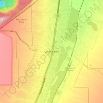
Nombre: Mapa topográfico Green Valley, altitud, relieve.
Lugar: Green Valley, Pima County, Arizona, 85614, United States (31.81425 -111.03370 31.89425 -110.95370)
Altitud media: 914 m
Altitud mínima: 698 m
Altitud máxima: 1 086 m
Haz una donación
Otros mapas topográficos
Haga clic en un mapa para ver su topografía, su altitud y su relieve.
Saguaro National Park
United States > Arizona > Pima County
Both districts conserve tracts of the Sonoran Desert, including ranges of significant hills, the Tucson Mountains in the west and the Rincon Mountains in the east. Elevations in the Tucson Mountain District range from 2,180 to 4,687 feet (664 to 1,429 m), the summit of Wasson Peak. Elevations within the Rincon…
Altitud media: 1 174 m
Saguaro National Park - Tucson Mountain District
United States > Arizona > Pima County > Marana
Both districts conserve tracts of the Sonoran Desert, including ranges of significant hills, the Tucson Mountains in the west and the Rincon Mountains in the east. Elevations in the Tucson Mountain District range from 2,180 to 4,687 feet (664 to 1,429 m), the summit of Wasson Peak. Elevations within the Rincon…
Altitud media: 794 m
Haz una donación
Drexel Heights
United States > Arizona > Pima County > Tucson
The area has numerous Saguaro cacti, and is positioned only a couple of miles south of the Saguaro National Park. The northern boundary of Drexel Heights is the Tucson Mountain Park. It is cut off from the rest of Tucson due to the topography of the Tucson Mountains, which are only crossed via a small number…
Altitud media: 786 m
Haz una donación
Pusch Ridge
United States > Arizona > Pima County
Pusch Ridge is primarily made up of three distinct peaks, including (from southwest to northeast in orientation) Pusch Peak, Bighorn Mountain, and Table Mountain. Pusch Peak is the westernmost point in the Santa Catalina Mountains, and rises in elevation over 2,000 feet (610 m) to a peak elevation of 5,366…
Altitud media: 1 184 m
Haz una donación
Haz una donación
Haz una donación