
Mapa topográfico Marvdasht
Mapa interactivo
Haga clic en el mapa para ver la altitud.
Acerca de este mapa
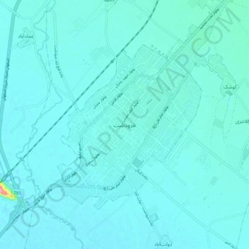
Nombre: Mapa topográfico Marvdasht, altitud, relieve.
Altitud media: 1 598 m
Altitud mínima: 1 587 m
Altitud máxima: 1 723 m
Marvdasht is one of the northern cities and also counties of Fars province. The city is located 45 km north of Shiraz and has an altitude of 1620 meters above the sea level. The county has an area of 3687 square kilometers and neighbors Arsenjan in the east, Pasargad in the north, Khorambid and Eghlid in the northwest, Sepidan in the southwest and Shiraz in the south. There are three cities in the county: Marvdasht, Seydan and Kamfirouz. Marvdasht as a county is divided into four districts: Central, Kamfirouz, Doroudzan and Seydan. Marvdasht has a cold weather in the hilly areas and moderate climate in other regions.
Otros mapas topográficos
Haga clic en un mapa para ver su topografía, su altitud y su relieve.
شهر مرودشت
Iran > Fars Province > Marvdasht County > شهر مرودشت
شهر مرودشت, Central District Marvdasht County, Marvdasht County, Fars Province, Iran
Altitud media: 1 598 m