
Mapa topográfico Montgomery
Mapa interactivo
Haga clic en el mapa para ver la altitud.
Acerca de este mapa
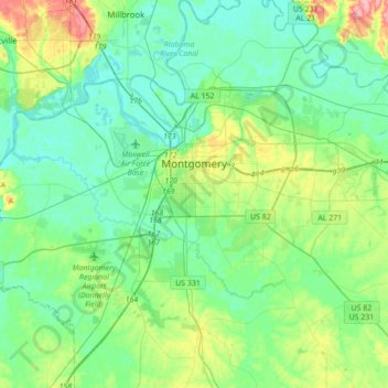
Nombre: Mapa topográfico Montgomery, altitud, relieve.
Lugar: Montgomery, Montgomery County, Alabama, United States (32.24992 -86.41987 32.43768 -86.07221)
Altitud media: 64 m
Altitud mínima: 37 m
Altitud máxima: 151 m
Montgomery is located at 32°21′42″N 86°16′45″W / 32.36167°N 86.27917°W / 32.36167; -86.27917.[25] According to the U.S. Census Bureau, the city has a total area of 156.2 square miles (405 km2), of which 155.4 square miles (402 km2) is land and 0.8 square miles (2.1 km2) (0.52%) is water. The city is built over rolling terrain at an elevation of about 220 feet (67 m) above sea level.[26]