
Mapa topográfico St. Joseph Island
Mapa interactivo
Haga clic en el mapa para ver la altitud.
St. Joseph Island
Its highest point, known colloquially and by surveyors as "the Mountain," is near the centre of the island near Carterton with an elevation of 345.6 m, which is about 169 m above Lake Huron.
Acerca de este mapa
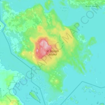
Nombre: Mapa topográfico St. Joseph Island, altitud, relieve.
Altitud media: 196 m
Altitud mínima: 171 m
Altitud máxima: 348 m