
Mapa topográfico San Antonio
Mapa interactivo
Haga clic en el mapa para ver la altitud.
Acerca de este mapa
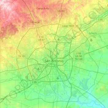
Nombre: Mapa topográfico San Antonio, altitud, relieve.
Lugar: San Antonio, Bexar County, Texas, United States (29.18626 -98.81319 29.73096 -98.22300)
Altitud media: 247 m
Altitud mínima: 117 m
Altitud máxima: 575 m
San Antonio is approximately 75 miles (121 km) to the southwest of its neighboring city, Austin, the state capital, about 190 miles (310 km) west of Houston, and about 250 miles (400 km) south of the Dallas–Fort Worth area. The city has a total area of 465.4 square miles (1,205.4 km2); 460.93 square miles (1,193.8 km2) of San Antonio's total area is land and 4.5 square miles (11.7 km2) of it is water. The city's gently rolling terrain is dotted with oak trees, forested land, mesquite, and cacti. The Texas Hill Country reaches into the far northern portions of the city. San Antonio sits on the Balcones Escarpment. Its altitude is approximately 662 feet (202 m) above sea level.
Otros mapas topográficos
Haga clic en un mapa para ver su topografía, su altitud y su relieve.
San Antonio
United States > Texas > Bexar County > San Antonio
San Antonio, Bexar County, Texas, 78205, United States
Altitud media: 218 m