
Mapa topográfico Touws River
Mapa interactivo
Haga clic en el mapa para ver la altitud.
Acerca de este mapa
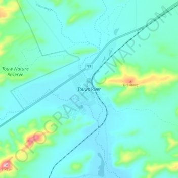
Nombre: Mapa topográfico Touws River, altitud, relieve.
Altitud media: 822 m
Altitud mínima: 760 m
Altitud máxima: 1 144 m
Touws River is located at an elevation of 770 metres (2,530 ft) on the southwestern edge of the Great Karoo, east of the Hex River Mountains and north of the Langeberg, at the point where the Donkeys River flows into the Touws River. It lies just to the south of the N1 highway, 180 kilometres (110 mi) by road from Cape Town. The railway line passes through the town, with the yards and depot being located just to the north-east; by rail it is 257 kilometres (160 mi) from Cape Town.
Otros mapas topográficos
Haga clic en un mapa para ver su topografía, su altitud y su relieve.
Worcester
South Africa > Western Cape > Cape Winelands District Municipality > Breede Valley Local Municipality
Worcester, Breede Valley Local Municipality, Cape Winelands District Municipality, Western Cape, 6849, South Africa
Altitud media: 252 m
De Doorns
South Africa > Western Cape > Cape Winelands District Municipality > Breede Valley Local Municipality
De Doorns, Breede Valley Local Municipality, Cape Winelands District Municipality, Western Cape, South Africa
Altitud media: 683 m
Matroos
South Africa > Western Cape > Cape Winelands District Municipality > Breede Valley Local Municipality
Matroos, Breede Valley Ward 3, Breede Valley Local Municipality, Cape Winelands District Municipality, Western Cape, South Africa
Altitud media: 1 642 m
Rawsonville
South Africa > Western Cape > Cape Winelands District Municipality > Breede Valley Local Municipality > Rawsonville
Rawsonville, Breede Valley Local Municipality, Cape Winelands District Municipality, Western Cape, South Africa
Altitud media: 231 m