
Mapa topográfico Mobile
Mapa interactivo
Haga clic en el mapa para ver la altitud.
Acerca de este mapa
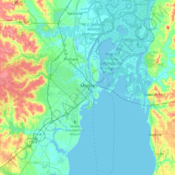
Nombre: Mapa topográfico Mobile, altitud, relieve.
Lugar: Mobile, Mobile County, Alabama, United States (30.56037 -88.22125 30.84346 -87.95662)
Altitud media: 14 m
Altitud mínima: -2 m
Altitud máxima: 76 m
According to the United States Census Bureau, the city has a total area of 180.1 square miles (466 km2), with 139.5 square miles (361 km2) of it being land, and 40.6 square miles (105.2 km2), or 22.5% of the total, being covered by water. The elevation in Mobile ranges from 10 feet (3 m) on Water Street in downtown to 211 feet (64 m) at the Mobile Regional Airport.