
Mapa topográfico Dubuque County
Mapa interactivo
Haga clic en el mapa para ver la altitud.
Acerca de este mapa
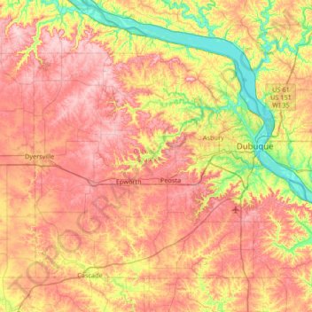
Nombre: Mapa topográfico Dubuque County, altitud, relieve.
Lugar: Dubuque County, Iowa, United States (42.29334 -91.13344 42.67462 -90.47332)
Altitud media: 284 m
Altitud mínima: 180 m
Altitud máxima: 381 m
The county seat is Dubuque, Iowa, which is located along the Mississippi River in the east-central portion of the county. Eastern Dubuque County is markedly different from the western portion in that its topography is very uneven. The city of Dubuque and surrounding areas adjacent to the Mississippi River have many steep hills, bluffs, and ravines. Also, the eastern portion is more heavily wooded than the west, which is mostly rolling farmland.
Otros mapas topográficos
Haga clic en un mapa para ver su topografía, su altitud y su relieve.
Dubuque
United States > Iowa > Dubuque County
Dubuque, Dubuque County, Iowa, United States
Altitud media: 241 m
Mississippi River
United States > Iowa > Dubuque County > Dubuque > Eagle Point
Mississippi River, Eagle Point, Dubuque, Dubuque County, Iowa, 52001, United States
Altitud media: 200 m
Mines of Spain State Recreation Area
United States > Iowa > Dubuque County > Dubuque
Mines of Spain State Recreation Area, Dubuque, Dubuque County, Iowa, United States
Altitud media: 217 m
Holy Cross
United States > Iowa > Dubuque County
Holy Cross, Dubuque County, Iowa, United States
Altitud media: 355 m
Farley
United States > Iowa > Dubuque County
Farley, Dubuque County, Iowa, 52046, United States
Altitud media: 335 m
Epworth
United States > Iowa > Dubuque County
Epworth, Dubuque County, Iowa, 52045, United States
Altitud media: 310 m