
Mapa topográfico Sierra de Guadarrama
Mapa interactivo
Haga clic en el mapa para ver la altitud.
Acerca de este mapa
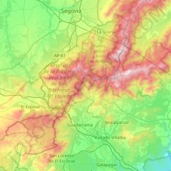
Nombre: Mapa topográfico Sierra de Guadarrama, altitud, relieve.
Altitud media: 1 241 m
Altitud mínima: 640 m
Altitud máxima: 2 421 m
The range runs southwest–northeast, extending from the province of Ávila in the southwest, through the Community of Madrid, to the province of Segovia in the northeast. The range measures approximately 80 kilometres (50 mi) in length. Its highest peak is Peñalara, 2,428 metres (7,966 ft) in elevation.