
Mapa topográfico Rafsanjan
Mapa interactivo
Haga clic en el mapa para ver la altitud.
Acerca de este mapa
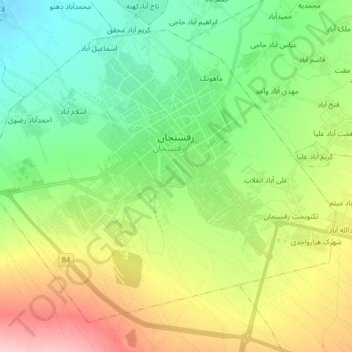
Nombre: Mapa topográfico Rafsanjan, altitud, relieve.
Lugar: Rafsanjan, بخش مرکزی, Rafsanjan County, Kerman Province, Iran (30.32710 55.90445 30.44527 56.06907)
Altitud media: 1 539 m
Altitud mínima: 1 477 m
Altitud máxima: 1 653 m
Rafsanjan is located in south part of the Lut desert, in north-west of Kerman province. The longitude of this city is 56 degrees east and the latitude is 30 degrees south. The Average distance between Kerman and this city is 110 km (68 mi). The city has an airport and railway (Tehran-Bandar Abbas route). Moreover, the altitude is 1,460 m (4,790 ft) and the land-measurement is approximately 10,687 km (6,641 mi). North part of Rafsanjan has a common frontier with Bafgh and Zarand; south part is neighboring with Bardsir and on west side with Anar and Shahre-Babak; finally east side of this beautiful city is neighboring with Kerman and Zarand. Rafsanjan has two seasonal rivers named as Shour and Giouderi. The mountains in the area are part of Zagros range, and Sarcheshmeh and Davaran are the most famous.