
Mapa topográfico Deal
Mapa interactivo
Haga clic en el mapa para ver la altitud.
Acerca de este mapa
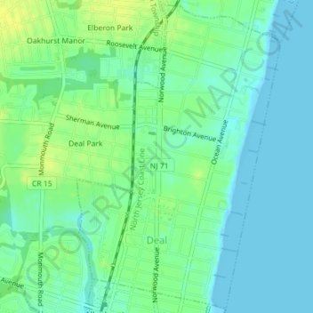
Nombre: Mapa topográfico Deal, altitud, relieve.
Lugar: Deal, Monmouth County, New Jersey, 07723, United States (40.23727 -74.00973 40.26345 -73.98668)
Altitud media: 8 m
Altitud mínima: -1 m
Altitud máxima: 19 m
Otros mapas topográficos
Haga clic en un mapa para ver su topografía, su altitud y su relieve.
Larrabees
United States > New Jersey > Monmouth County > Howell Township
Larrabees, Howell Township, Monmouth County, New Jersey, 08701, United States
Altitud media: 19 m
Bucks Mill
United States > New Jersey > Monmouth County > Colts Neck Township
Bucks Mill, Colts Neck Township, Monmouth County, New Jersey, 07722, United States
Altitud media: 34 m
Oceanic
United States > New Jersey > Monmouth County > Rumson
Oceanic, Rumson, Monmouth County, New Jersey, 07760, United States
Altitud media: 16 m
Hazlet Township
United States > New Jersey > Monmouth County
Hazlet Township, Monmouth County, New Jersey, 07730, United States
Altitud media: 15 m
Avon-by-the-Sea
United States > New Jersey > Monmouth County
Avon-by-the-Sea, Monmouth County, New Jersey, 07717, United States
Altitud media: 3 m
Upper Freehold Township
United States > New Jersey > Monmouth County
Upper Freehold Township, Monmouth County, New Jersey, United States
Altitud media: 44 m
Freewood Acres
United States > New Jersey > Monmouth County > Howell Township
Freewood Acres, Howell Township, Monmouth County, New Jersey, 07731, United States
Altitud media: 37 m
Loch Arbour
United States > New Jersey > Monmouth County
Loch Arbour, Monmouth County, New Jersey, United States
Altitud media: 4 m
Morganville
United States > New Jersey > Monmouth County > Marlboro Township
Morganville, Marlboro Township, Monmouth County, New Jersey, 07751, United States
Altitud media: 43 m
Wanamassa
United States > New Jersey > Monmouth County > Ocean Township
Wanamassa, Ocean Township, Monmouth County, New Jersey, United States
Altitud media: 13 m
Aberdeen Township
United States > New Jersey > Monmouth County
Aberdeen Township, Monmouth County, New Jersey, United States
Altitud media: 17 m
Villa Park
United States > New Jersey > Monmouth County > Spring Lake Heights
Villa Park, Spring Lake Heights, Monmouth County, New Jersey, 08750, United States
Altitud media: 8 m
Town Brook
United States > New Jersey > Monmouth County > Middletown Township
Town Brook, Middletown Township, Monmouth County, New Jersey, 07748, United States
Altitud media: 27 m
Hendrickson Corners
United States > New Jersey > Monmouth County > Middletown Township
Hendrickson Corners, Middletown Township, Monmouth County, New Jersey, 07748, United States
Altitud media: 22 m
Rumson
United States > New Jersey > Monmouth County
Rumson, Monmouth County, New Jersey, 07760, United States
Altitud media: 5 m
Monmouth Beach
United States > New Jersey > Monmouth County
Monmouth Beach, Monmouth County, New Jersey, 07750, United States
Altitud media: 1 m
Allentown
United States > New Jersey > Monmouth County
Allentown, Monmouth County, New Jersey, United States
Altitud media: 30 m
Oak Glen
United States > New Jersey > Monmouth County > Howell Township
Oak Glen, Howell Township, Monmouth County, New Jersey, 07731, United States
Altitud media: 29 m
Oceanport
United States > New Jersey > Monmouth County
Oceanport, Monmouth County, New Jersey, United States
Altitud media: 5 m
Long Branch
United States > New Jersey > Monmouth County > Long Branch
Long Branch, Monmouth County, New Jersey, 07740, United States
Altitud media: 10 m
Pine Brook
United States > New Jersey > Monmouth County > Tinton Falls
Pine Brook, Tinton Falls, Monmouth County, New Jersey, 07724, United States
Altitud media: 26 m
Manasquan
United States > New Jersey > Monmouth County
Manasquan, Monmouth County, New Jersey, United States
Altitud media: 7 m
Freehold
United States > New Jersey > Monmouth County
Freehold, Monmouth County, New Jersey, United States
Altitud media: 53 m
New Monmouth
United States > New Jersey > Monmouth County > Middletown Township
New Monmouth, Middletown Township, Monmouth County, New Jersey, 07718, United States
Altitud media: 15 m
Hamilton
United States > New Jersey > Monmouth County > Neptune Township
Hamilton, Neptune Township, Monmouth County, New Jersey, 07753, United States
Altitud media: 25 m
Marlboro Township
United States > New Jersey > Monmouth County
Marlboro Township, Monmouth County, New Jersey, United States
Altitud media: 39 m
Wall Township
United States > New Jersey > Monmouth County
Wall Township, Monmouth County, New Jersey, United States
Altitud media: 18 m
Tinton Falls
United States > New Jersey > Monmouth County
Tinton Falls, Monmouth County, New Jersey, United States
Altitud media: 23 m
Middletown Township
United States > New Jersey > Monmouth County
Middletown Township, Monmouth County, New Jersey, United States
Altitud media: 18 m
Bradley Beach
United States > New Jersey > Monmouth County
Bradley Beach, Monmouth County, New Jersey, 07720, United States
Altitud media: 4 m
Holmdel Township
United States > New Jersey > Monmouth County
Holmdel Township, Monmouth County, New Jersey, 07733, United States
Altitud media: 39 m
Fort Plains
United States > New Jersey > Monmouth County > Howell Township
Fort Plains, Howell Township, Monmouth County, New Jersey, 07731, United States
Altitud media: 36 m
Manalapan Township
United States > New Jersey > Monmouth County
Manalapan Township, Monmouth County, New Jersey, 07726, United States
Altitud media: 41 m
Red Bank
United States > New Jersey > Monmouth County
Red Bank, Monmouth County, New Jersey, United States
Altitud media: 11 m
Holmdel
United States > New Jersey > Monmouth County > Holmdel
Holmdel, Holmdel Township, Monmouth County, New Jersey, 07722, United States
Altitud media: 42 m
Sea Bright
United States > New Jersey > Monmouth County > Sea Bright
Sea Bright, Monmouth County, New Jersey, United States
Altitud media: 5 m
Asbury Park
United States > New Jersey > Monmouth County > Asbury Park
Asbury Park, Monmouth County, New Jersey, 07711, United States
Altitud media: 6 m
Spring Valley
United States > New Jersey > Monmouth County > Spring Valley
Spring Valley, Marlboro Township, Monmouth County, New Jersey, 07751, United States
Altitud media: 28 m
Sea Girt
United States > New Jersey > Monmouth County
Sea Girt, Monmouth County, New Jersey, 08750, United States
Altitud media: 3 m
Carrs Tavern
United States > New Jersey > Monmouth County > Millstone Township > Carrs Tavern
Carrs Tavern, Millstone Township, Monmouth County, New Jersey, 08510, United States
Altitud media: 53 m
Farmingdale
United States > New Jersey > Monmouth County
Farmingdale, Monmouth County, New Jersey, United States
Altitud media: 23 m
Freehold
United States > New Jersey > Monmouth County > Freehold Borough > Freehold
Freehold, Freehold Borough, Monmouth County, New Jersey, 07728-1406, United States
Altitud media: 45 m
Freneau
United States > New Jersey > Monmouth County > Matawan > Freneau
Freneau, Matawan, Monmouth County, New Jersey, 07747-3258, United States
Altitud media: 24 m
Collingwood Park
United States > New Jersey > Monmouth County > Collingwood Park
Collingwood Park, Wall Township, Monmouth County, New Jersey, 07727, United States
Altitud media: 31 m
Union Beach
United States > New Jersey > Monmouth County > Union Beach
Union Beach, Monmouth County, New Jersey, United States
Altitud media: 2 m
Sea Girt
United States > New Jersey > Monmouth County > Sea Girt > Sea Girt
Sea Girt, Monmouth County, New Jersey, 08750, United States
Altitud media: 4 m
Fairfield
United States > New Jersey > Monmouth County > Howell Township
Fairfield, Howell Township, Monmouth County, New Jersey, 07710, United States
Altitud media: 31 m
Belmar
United States > New Jersey > Monmouth County
Belmar, Monmouth County, New Jersey, 07715, United States
Altitud media: 3 m
West Long Branch
United States > New Jersey > Monmouth County > West Long Branch
West Long Branch, Monmouth County, New Jersey, United States
Altitud media: 11 m
Bradley Park
United States > New Jersey > Monmouth County > Neptune > Bradley Park
Bradley Park, Neptune, Neptune Township, Monmouth County, New Jersey, 07720, United States
Altitud media: 7 m