
Haz una donación
Mapa topográfico 달터마을
Haga clic en el mapa para ver la altitud.
Haz una donación
Acerca de este mapa
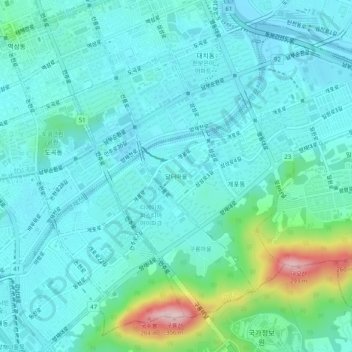
Nombre: Mapa topográfico 달터마을, altitud, relieve.
Lugar: 달터마을, Gaepo 2(i)-dong, Gangnam-gu, Seoul, 06324, South Korea (37.46506 127.04143 37.50506 127.08143)
Altitud media: 54 m
Altitud mínima: 7 m
Altitud máxima: 276 m
Haz una donación
Otros mapas topográficos
Haga clic en un mapa para ver su topografía, su altitud y su relieve.
Haz una donación
Haz una donación
Seodaemun-gu
Seodaemun District incorporates residential areas and historical areas including Bongwon Temple, Sinchon Railway Station (the oldest train station in Seoul) and Seodaemun Prison History Hall. Also it has a historic culture site "Seodaemun Independence Park." This place located at Dongnimmun station, includes a…
Altitud media: 70 m
Haz una donación
Haz una donación
Yongsan-gu
Yongsan is located next to the Han River, with level ground in the west of the district which has been used for transportation (rail) and commercial use since the early 20th century. To the east and north in the land is steeper and rises towards Namsan which lies to the north. Namsan has an elevation of 243m…
Altitud media: 39 m
Haz una donación
Haz una donación
Haz una donación
Haz una donación
Jongno-gu
Jongno district was historically the center of Joseon & latterly the Korean Empire and retained its prominence in the modern era after the establishment of the Republic of Korea. Hanyang, the capital of Joseon, included Jongno district and Jung district. In October, 1394 (the third year of King Taejo's reign),…
Altitud media: 143 m
Haz una donación
Haz una donación
Haz una donación
Haz una donación
Haz una donación
Seodaemun-gu
Seodaemun District incorporates residential areas and historical areas including Bongwon Temple, Sinchon Railway Station (the oldest train station in Seoul) and Seodaemun Prison History Hall. Also it has a historic culture site "Seodaemun Independence Park." This place located at Dongnimmun station, includes a…
Altitud media: 70 m
Haz una donación
Haz una donación
Haz una donación
Yongsan-gu
Yongsan is located next to the Han River, with level ground in the west of the district which has been used for transportation (rail) and commercial use since the early 20th century. To the east and north in the land is steeper and rises towards Namsan which lies to the north. Namsan has an elevation of 243m…
Altitud media: 39 m
Haz una donación
Haz una donación
Yongsan-gu
Yongsan is located next to the Han River, with level ground in the west of the district which has been used for transportation (rail) and commercial use since the early 20th century. To the east and north in the land is steeper and rises towards Namsan which lies to the north. Namsan has an elevation of 243m…
Altitud media: 39 m
Seodaemun-gu
Seodaemun District incorporates residential areas and historical areas including Bongwon Temple, Sinchon Railway Station (the oldest train station in Seoul) and Seodaemun Prison History Hall. Also it has a historic culture site "Seodaemun Independence Park." This place located at Dongnimmun station, includes a…
Altitud media: 70 m
Haz una donación
Jongno-gu
Jongno district was historically the center of Joseon & latterly the Korean Empire and retained its prominence in the modern era after the establishment of the Republic of Korea. Hanyang, the capital of Joseon, included Jongno district and Jung district. In October, 1394 (the third year of King Taejo's reign),…
Altitud media: 143 m
Haz una donación
Haz una donación