
Mapa topográfico Palakollu
Mapa interactivo
Haga clic en el mapa para ver la altitud.
Acerca de este mapa
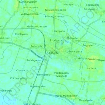
Nombre: Mapa topográfico Palakollu, altitud, relieve.
Altitud media: 7 m
Altitud mínima: 2 m
Altitud máxima: 12 m
At an average altitude of 1.5 metres (4.9 ft), Palakollu town is situated on National Highway 165 (India) and National Highway 216 (India). It is bounded by Krishna district and Vijayawada on the west, Amalapuram and Bay of Bengal on the east, Narasapuram and Bay of Bengal on the south, and Rajahmundry and East Godavari district on the north.[13]