
Mapa topográfico Houston
Mapa interactivo
Haga clic en el mapa para ver la altitud.
Acerca de este mapa
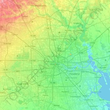
Nombre: Mapa topográfico Houston, altitud, relieve.
Lugar: Houston, Harris County, Texas, United States (29.53707 -95.90974 30.11035 -95.01205)
Altitud media: 25 m
Altitud mínima: -3 m
Altitud máxima: 98 m
Much of the city was built on forested land, marshes, or swamps, and all are still visible in surrounding areas. Flat terrain and extensive greenfield development have combined to worsen flooding. Downtown stands about 50 feet (15 m) above sea level, and the highest point in far northwest Houston is about 150 feet (46 m) in elevation. The city once relied on groundwater for its needs, but land subsidence forced the city to turn to ground-level water sources such as Lake Houston, Lake Conroe, and Lake Livingston. The city owns surface water rights for 1.20 billion US gallons (4.5 Gl) of water a day in addition to 150 million US gallons (570 Ml) a day of groundwater.
Otros mapas topográficos
Haga clic en un mapa para ver su topografía, su altitud y su relieve.
Memorial Park
United States > Texas > Harris County > Houston
Memorial Park, Houston, Harris County, Texas, 77007, United States
Altitud media: 21 m
Sylvester Turner Park
United States > Texas > Harris County > Houston
Sylvester Turner Park, Houston, Harris County, Texas, United States
Altitud media: 27 m