
Haz una donación
Mapa topográfico Williams
Haga clic en el mapa para ver la altitud.
Haz una donación
Williams
Bill Williams Mountain rises to an elevation of 9,256 feet (2,821 m) just south of Williams. According to the United States Census Bureau, the city has a total area of 43.8 square miles (113 km2), of which 43.5 square miles (113 km2) is land and 0.3 square miles (0.78 km2), or 0.66%, is water.
Haz una donación
Acerca de este mapa
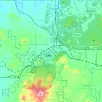
Nombre: Mapa topográfico Williams, altitud, relieve.
Lugar: Williams, Coconino County, Arizona, 86046, United States (35.18978 -112.24731 35.32272 -112.10644)
Altitud media: 2 131 m
Altitud mínima: 1 962 m
Altitud máxima: 2 811 m
Haz una donación
Otros mapas topográficos
Haga clic en un mapa para ver su topografía, su altitud y su relieve.
Flagstaff
United States > Arizona > Coconino County
Flagstaff is the county seat of Coconino County. According to the United States Census Bureau, the city has a total area of 63.9 square miles (165.5 km2), of which only 0.03 square miles (0.08 km2) (0.08%) is water. Flagstaff lies at approximately 7,000 feet (2,130 m) elevation, and is surrounded by the…
Altitud media: 2 176 m