
Mapa topográfico Eghlid
Mapa interactivo
Haga clic en el mapa para ver la altitud.
Acerca de este mapa
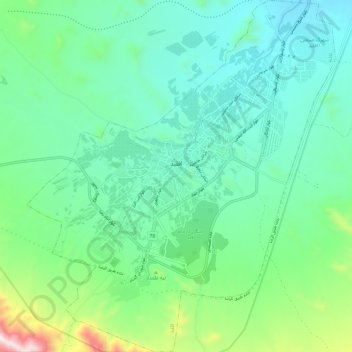
Nombre: Mapa topográfico Eghlid, altitud, relieve.
Altitud media: 2 310 m
Altitud mínima: 2 115 m
Altitud máxima: 2 984 m
Eqlid is located 22 km west of the Expressway between Isfahan and Shiraz. The population of Eghlid is about 45,000 (2011). It is located close to the mountain chain Zagros and is one of the highest elevations (a mountain peak known as Bel) among Iran cities (2250 meters). It is also close to the desert city of Abarqu, making it a city in the border of high mountain and desert. It has a dry and cold weather, and some of its mountain peaks are covered by snow throughout the year. It is an agriculture city and its main products are wheat, barley, potato and fruits like grapes, walnut, apple, and pear. Its main road is Emam Khomeini Boulevard.
Otros mapas topográficos
Haga clic en un mapa para ver su topografía, su altitud y su relieve.
Dordaneh
Iran > Fars Province > Eqlid County > Ahmadabad RD
Dordaneh, Ahmadabad RD, Hasanabad District, Eqlid County, Fars Province, Iran
Altitud media: 2 236 m