
Haz una donación
Mapa topográfico Huế
Haga clic en el mapa para ver la altitud.
Haz una donación
Huế
The Perfume River (called Sông Hương or Hương Giang in Vietnamese) passes through the center of province. The province also accommodates the Tam Giang–Cau Hai lagoon, the largest lagoon in Southeast Asia, which is 68 kilometres (42 mi) long with a surface area of 220 square kilometres (85 sq mi). The province is divided into four distinct zones: mountainous areas, hills, plains, and lagoons separated from the sea by sandbanks. It has a coastline of 128 kilometres (80 mi) with extensive beaches. The mountains, located along the western and southwestern borders, cover more than half of the province’s total area, with elevations ranging from 500 metres (1,600 ft) to 1,480 metres (4,860 ft). The hills, which lie between the mountains and the plains, account for about one-third of the territory and range in height from 20 metres (66 ft) to 200 metres (660 ft), with occasional peaks rising to 400 metres (1,300 ft). The plains occupy roughly one-tenth of the surface area, reaching elevations of up to 20 metres (66 ft) above sea level. The lagoons, located between the hills, represent the remaining 5% of the province’s area.
Haz una donación
Acerca de este mapa
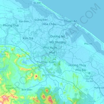
Nombre: Mapa topográfico Huế, altitud, relieve.
Lugar: Huế, 54000, Vietnam (16.30393 107.42634 16.62393 107.74634)
Altitud media: 30 m
Altitud mínima: -3 m
Altitud máxima: 563 m
Haz una donación
Otros mapas topográficos
Haga clic en un mapa para ver su topografía, su altitud y su relieve.