
Haz una donación
Mapa topográfico Eickelborn
Haga clic en el mapa para ver la altitud.
Haz una donación
Acerca de este mapa
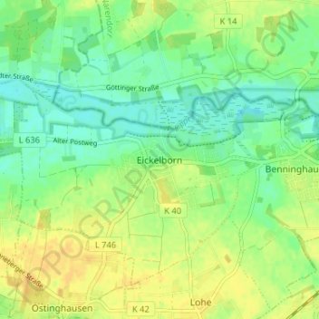
Nombre: Mapa topográfico Eickelborn, altitud, relieve.
Altitud media: 79 m
Altitud mínima: 67 m
Altitud máxima: 91 m
Haz una donación
Otros mapas topográficos
Haga clic en un mapa para ver su topografía, su altitud y su relieve.
Lipperode
Deutschland > Nordrhein-Westfalen > Kreis Soest > Lippstadt
Doch was ereignete sich tatsächlich? Im Dezember 1812 befanden sich Teile der französischen Armee und auch das Bataillon Lippe auf dem Rückzug von Kowno (Ort im Süden Litauens) über Gumbinen nach Tilsit. Es war Winter und natürlich sehr kalt, die Straßen waren glatt und verdreckt, die Flucht wenig…
Altitud media: 78 m
Haz una donación
Dedinghausen
Deutschland > Nordrhein-Westfalen > Kreis Soest > Lippstadt
Der neue Schulkomplex bestand aus einer Grundschule, einer Hauptschule sowie einer Sport- und einer Lehrschwimmhalle. Nach ihrer Schließung wurde die Hauptschule zur Westfälischen Wirtschaftsakademie für Physiotherapie und Ergotechnik umgebaut. Die Grundschule und die Berufsakademie bilden gemeinsam einen…
Altitud media: 89 m
Haz una donación