
Mapa topográfico Île de Ré
Mapa interactivo
Haga clic en el mapa para ver la altitud.
Acerca de este mapa
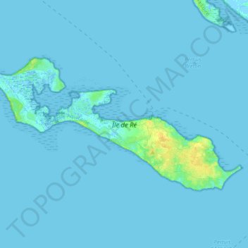
Nombre: Mapa topográfico Île de Ré, altitud, relieve.
Altitud media: 1 m
Altitud mínima: -3 m
Altitud máxima: 16 m
Île de Ré (French pronunciation: [il də ʁe]; variously spelled Rhé or Rhéa; Poitevin: ile de Rét; English: Isle of Ré, /reɪ/ RAY) is an island off the Atlantic coast of France near La Rochelle, Charente-Maritime, on the northern side of the Pertuis d'Antioche strait. Its highest point has an elevation of 20 metres (66 feet). It is 30 kilometres (19 miles) long and five kilometres (3 miles) wide. The 2.9 km (1.8 mi) Île de Ré bridge, completed in 1988, connects it to La Rochelle on the mainland.