
Mapa topográfico Pinlaung Township
Mapa interactivo
Haga clic en el mapa para ver la altitud.
Acerca de este mapa
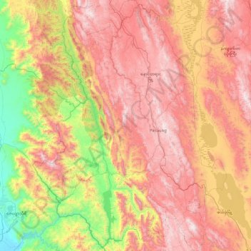
Nombre: Mapa topográfico Pinlaung Township, altitud, relieve.
Altitud media: 964 m
Altitud mínima: 84 m
Altitud máxima: 1 838 m
Pinlaung Township accounts for the largest area of tea cultivation in southern Shan State. The Tea grown here is of the Assamica cultivar. Tea plantations in the area cover 12,000 acres, with half of the cultivation taking place in the higher elevations of Le Hlaung, 10 miles from Pinlaung. In the Koe Khaung ward, tea production is refined and the tea coming from the nearly 100 tea-producing households is highly sought after. Farmers here use stoves with chimneys and clean pans for roasting, which creates a smoother teat that fetches higher prices than other teas in the region.