
Gracias por apoyar a este sitio ❤️
Haz una donación
Haz una donación
Mapa topográfico Hastings Lake
Haga clic en el mapa para ver la altitud.
Gracias por apoyar a este sitio ❤️
Haz una donación
Haz una donación
Acerca de este mapa
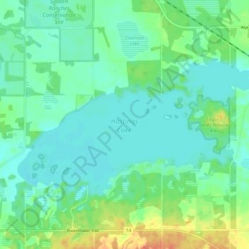
Nombre: Mapa topográfico Hastings Lake, altitud, relieve.
Lugar: Hastings Lake, Strathcona County, Alberta, Canada (53.40348 -112.95416 53.43410 -112.86438)
Altitud media: 744 m
Altitud mínima: 733 m
Altitud máxima: 772 m
Gracias por apoyar a este sitio ❤️
Haz una donación
Haz una donación
Otros mapas topográficos
Haga clic en un mapa para ver su topografía, su altitud y su relieve.