
Mapa topográfico Nazareth
Mapa interactivo
Haga clic en el mapa para ver la altitud.
Acerca de este mapa
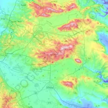
Nombre: Mapa topográfico Nazareth, altitud, relieve.
Lugar: Nazareth, Jezreel Subdistrict, North District, 16161, Israel (32.54663 35.14482 32.86663 35.46482)
Altitud media: 151 m
Altitud mínima: -128 m
Altitud máxima: 565 m
As of the early 1990s, no city plans drafted by Nazareth Municipality have been approved by the government (both the British Mandate and later Israel) since 1942. This has left many people in Nazareth who vote in the city's municipal elections and receive services from its municipality effectively outside of the city's jurisdiction. Such areas include the Sharqiya and Jabal el-Daula quarters which are in Nazareth Illit's jurisdiction and whose residents had to acquire building permits from the latter city. Similarly, the Bilal neighborhood of the Safafra Quarter is located within Reineh's jurisdiction. In 1993, the residents of Bilal became official residents of Reineh. Nazareth's municipal plans for expansion prior to the establishment of Nazareth Illit, were to the north and east, areas that the latter city now occupy. Arab satellite towns are closely located to the north, west and southwest. Thus, the remaining area within the city's municipal boundaries available for expansion were to the northwest and the south, where the topography restricted urban development. After lobbying the Knesset and the Interior Ministry, el-Zoubi was able to have areas to the northwest of the city annexed to the municipality.
Otros mapas topográficos
Haga clic en un mapa para ver su topografía, su altitud y su relieve.
Nazareth
Israel > North District > Nazareth
Nazareth, Jezreel Subdistrict, North District, 16161, Israel
Altitud media: 359 m