
Mapa topográfico Phoenix
Mapa interactivo
Haga clic en el mapa para ver la altitud.
Acerca de este mapa
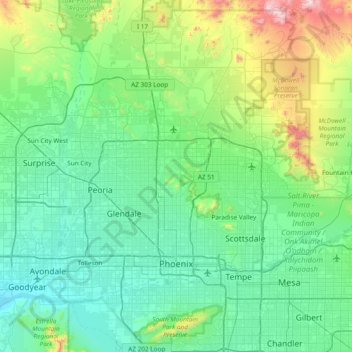
Nombre: Mapa topográfico Phoenix, altitud, relieve.
Lugar: Phoenix, Maricopa County, Arizona, United States (33.29037 -112.32403 33.91838 -111.92553)
Altitud media: 481 m
Altitud mínima: 267 m
Altitud máxima: 1 510 m
Phoenix is in the south-central portion of Arizona; about halfway between Tucson to the southeast and Flagstaff to the north, in the southwestern United States. By car, the city is approximately 150 miles (240 kilometers) north of the US–Mexico border at Sonoyta and 180 mi (290 km) north of the border at Nogales. The metropolitan area is known as the "Valley of the Sun" due to its location in the Salt River Valley. It lies at a mean elevation of 1,086 feet (331 m), in the northern reaches of the Sonoran Desert.
Otros mapas topográficos
Haga clic en un mapa para ver su topografía, su altitud y su relieve.
Sun City
United States > Arizona > Maricopa County > Peoria
Sun City, Peoria, Maricopa County, Arizona, 85351, United States
Altitud media: 356 m
Gilbert
United States > Arizona > Maricopa County
Gilbert, Maricopa County, Arizona, United States
Altitud media: 383 m
Surprise
United States > Arizona > Maricopa County > Surprise
Surprise, Maricopa County, Arizona, 85374, United States
Altitud media: 410 m