
Mapa topográfico Glencoe
Mapa interactivo
Haga clic en el mapa para ver la altitud.
Acerca de este mapa
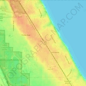
Nombre: Mapa topográfico Glencoe, altitud, relieve.
Altitud media: 194 m
Altitud mínima: 175 m
Altitud máxima: 212 m
The village is surrounded on three sides by upper-income communities, with Highland Park on the north, Northbrook on the west, and Winnetka to the south. The Skokie Lagoons are located in the forest preserve to the immediate west of the village. The same forest preserve has a bicycle trail that connects to other forest preserves to the south. In the village, the Green Bay Trail allows bicyclists to travel as far south as Wilmette and north past Lake Forest. The highest point of elevation in Glencoe is 690 feet (210 m) above sea level along Green Bay Road in the northern part of the village.
Otros mapas topográficos
Haga clic en un mapa para ver su topografía, su altitud y su relieve.
Wood Oaks Green Park Sled Hill
United States > Illinois > Cook County > Northbrook
Wood Oaks Green Park Sled Hill, Northbrook, Northfield Township, Cook County, Illinois, 60062, United States
Altitud media: 202 m
Chicago
United States > Illinois > Cook County
Chicago, Cook County, Illinois, United States
Altitud media: 182 m
Schaumburg Road Grasslands
United States > Illinois > Cook County
Schaumburg Road Grasslands, Hanover Township, Cook County, Illinois, 60107, United States
Altitud media: 246 m