
Mapa topográfico Papeete
Mapa interactivo
Haga clic en el mapa para ver la altitud.
Acerca de este mapa
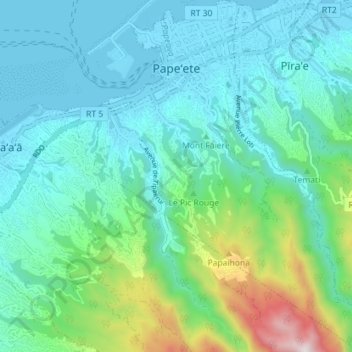
Nombre: Mapa topográfico Papeete, altitud, relieve.
Altitud media: 224 m
Altitud mínima: -2 m
Altitud máxima: 1 133 m
Previously, during the construction of the Faʻaiere water tower with a capacity of 150,000 litres for the drinking water supply of the city of Papeʻetē, a difference in altitude of 37 metres (121 ft) was overcome with a light railway laid on a 220 metres (720 ft) long inclined plane. A winch driven by a 12-horsepower Fowler or Decauville locomobile carried three narrow gauge railway trucks at a time, consuming up to 200 kilograms (440 lb) of coal per day for about sixty journeys. Paul Decauville mentioned in a letter to Governor Theodore Lacascade, dated 18 June 1891, an order for "15 kilometres (9.3 mi) of 600 mm (1 ft 11+5⁄8 in) portable rail tracks and about 12,000 francs of rolling stock, payable in three years," presumably for a tramway from Papeʻetē to Punaʻauia operated by hand or animals.
Otros mapas topográficos
Haga clic en un mapa para ver su topografía, su altitud y su relieve.
Tahiti
France > French Polynesia > Windward Islands
Tahiti, Windward Islands, French Polynesia, France
Altitud media: 160 m
Punaʻauiʻa
France > French Polynesia > Windward Islands
Punaʻauiʻa, Windward Islands, French Polynesia, France
Altitud media: 215 m
Area
France > French Polynesia > Windward Islands > Taiarapu-Ouest
Area, Taiarapu-Ouest, Windward Islands, French Polynesia, France
Altitud media: 229 m
Arue
France > French Polynesia > Windward Islands
Arue, Windward Islands, French Polynesia, 98701, France
Altitud media: 14 m